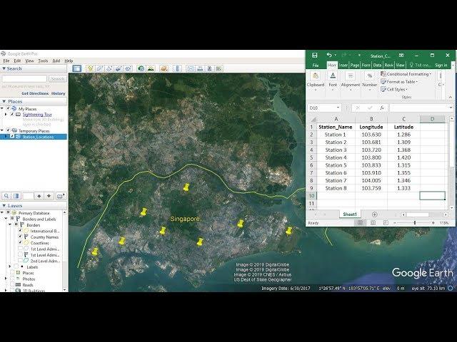
Importing Excel Coordinates to ArcMap and Plotting
Комментарии:

Thank you
Ответить
Thank you
Ответить
Thank you
Ответить
so how do i copy the shape file created to word document?
Ответить
Thank you for your video
Ответить
In my case points are plotted but attribute table is showing nothing
Ответить
Thanks soo much
Ответить
thanks
Ответить
Great video my friend, sure helped alot! keep up the good work!
Ответить
tHANK YOU SIR FOR HELPING US SAVE THE WORLD WITH U
OR GIS

How to write station name in study area?
Ответить
Why can’t I upload my excel file to arcgis? There’s an error message saying that “failed to connect to database. An underlying database error occurred. Class not registered “ however i saved the excel data sheet as Excel 97-2003 workbook .
please help me to resolve it!

Thanks
Ответить
The point did not appear when add like you? I did not found any solution on the internet why it did not appear. Please help me?
Ответить
How shape file was prepared
Ответить
I have coordinates collected in UTM but since GIS requires lat/long is there an easy way to convert it without needing to do it manually
Ответить
Sir, Please make a video on how do I calculate the Positional Accuracy of GCP points?
Ответить
Thank you for this video! It was exactly what I was looking for to help plot my points. Just a quick question if you could help please. When I uploaded the data and plotted the points, I was unable to get the attribute data. Is there anyway I can get it to display? Could there be an issue with my formatting on excel? Any help to get my attribute data to display is very much appreciated. Thank you.
Ответить
Thanks so much SIR
Ответить
sir latitude and longitude option are not shown what i do, where the whole process is same
Ответить
Dear sir your video is very good always. Please make a video to generate the geotiff raster by CSV data containing lat lon and data using Python
Ответить
Thanks! It was very helpful.
I have question, How can we add jurisdictional boundaries of stations. suppose we are working on police stations in a city, so, a police station must have jurisdiction, so what data need to collected and what terminologies are to use?

Many many thanks brother . I was spending a lot of time but could not solve the problem but your only 4 minute video solve my problem .Highly recommended your channel
Ответить
Thank you so much. Clear instructions
Ответить
Thank you so much.. Every step and point is well explained but the most best part of this video is your voice...
Ответить
when I add the station coordinate, the latitude and longitude don't show up?
Ответить
Thanks, a good demonstration <3
Ответить
It was great job .can you insert the UTM coordinates instead of lat.Log...?
Ответить
Thank you, this is exactly what I need to do in many situations
Ответить
Madhawa aiya... ❤️
Ответить
Thanks !
Ответить
Amazing!! Thank you so much 🙂
Ответить
Thanks for ur efforts, but when I come to to put the x and y into their places I can't find the columns ?):why
Ответить
where to get the basemap for Singapore?
Ответить
thanks brother!!! u made my live longer!! huaa
Ответить
ArCGIS student here. Thanks so much
Ответить
Thank you so much brother. You are a great man
Ответить
Hi, i'm trying to put my x and y coordinates in excel but it's not working. For example, i have this coordinate 52.274967, 4.794477. But when i put it in excel it turns into 52.274.967 and 4.794.477
I can't get these locations to show up in ArcGIS. I tried converting the cells to text instead of number but then i can't add them in ArcGIS either. What can i do to remove that 2nd dot because excel keeps adding it

tk yu, im from Indonesia
Ответить
it was very useful tutorial thank you
Ответить
Very Helpful, thanks!
Ответить
Good! Thank you
Ответить
Hi ! I am totally new to ArcGIS. I am just wondering if you could just add your points on Singapore from any of the default basemaps instead of creating a shapefile for Singapore. Would adding all the other layers to the basemap reduce coordinate related errors ?
Ответить
Thank u so much 👏🏻👏🏻👏🏻
Ответить
Awesome
Ответить
Thanks, dude~
Ответить
Thanks a lot.
Ответить
Very informative video..sir please tell me how to make a study map using arcgis.i have made an excel file that contains latitude and longitude value . My thesis is on hospitals in Lahore Pakistan.
Ответить
Wonderful Video! How can you make it so Singapore looks more like a satellite image/realistic instead of just one plain color?
Ответить
![How To Reset iPhone Screen Time Passcode #shorts [Quick Tip] How To Reset iPhone Screen Time Passcode #shorts [Quick Tip]](https://invideo.cc/img/upload/WXphVENNekYxUGE.jpg)
![[FREE] Lil Tjay Type Beat 2021 - "Regret" | @JpBeatz [FREE] Lil Tjay Type Beat 2021 - "Regret" | @JpBeatz](https://invideo.cc/img/upload/a3ktNlY3UHhyMFM.jpg)


