Geodetic Densify Tool ArcGIS
Geodetic Densify Tool, Features Toolset, Data Management ArcToolbox
Summary
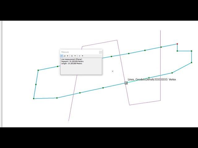
Creates new features by replacing input feature's segments with densified approximations of geodesic segments. Four type of geodesic segments can be constructed: Geodesic, Great Elliptic, Loxodrome, and Normal Section.
Usage
The end points of the segments will be connected using a geodetic approximation. The input segment type is irrelevant; linear and nonlinear (circular arc, elliptic arc, and Bezier curve) segments with common end points will yield the same output.
No output feature will be written for input features made of a single segment with coincident start and end points. For example, a polygon feature made of a single circular arc will not be written to the output.
geodetic ,geodetic lines ,geodetic datums ,geodetic datum (literature subject) ,shape tools ,qgis shape tools ,data management tools ,tools ,shape tools walk through ,geodesy ,defense ,solutions ,geomatics ,subsidence ,#shapetools ,geometryengine ,geographic information system ,dynamic situational awareness ,geographic information systems ,recortar entidades ,expandir entidades ,service definition ,sistemas de informacion geografica ,fill missing geo data
شرح الأداة:
https://gisforwe.blogspot.com/2021/10/dice-and-feature-envelope-to-polygon.html
لمتابعة موقع GISforWE من هنا:
https://bit.ly/GISforWE
تنزيل برامج ArcGIS و ArcGIS Pro مدى الحياة:
https://gisforwe.blogspot.com/2022/11/%20ArcGIS.html
https://gisforwe.blogspot.com/2021/05/ArcGIS10.8.html
موقع لكل مهتم في مجال نظم المعلومات الجغرافية GIS من هنا:
https://exe.io/GISforWE
احترف التعامل مع البيانات الجغرافية من خلال برامج ArcGIS:
https://exe.io/GISforWE-1
تعلم اساسيات إنشاء قواعد البيانات الجغرافية من هنا:
https://exe.io/GISforWE-2
اليك صفحه ومجموعة على الفيس بوك لتعلم أكثر بما يخص نظم المعلومات الجغرافية (GIS) و برامج ArcGIS من خلال هذه الروابط:
مجموعة على الفيس بوك ArcGIS :
https://www.facebook.com/groups/486795389231905
مجموعة على الفيس بوك GIS for WE - ArcGIS:
https://www.facebook.com/groups/ESRI.ArcGIS
صفحة الفيس بوك GIS for WE:
https://www.facebook.com/profile.php?id=100053947103452
رابط فيديو مقدمة تعلم على برامج ArcGIS بثلاثة مراحل :
https://exe.io/GISforWE-3
#ArcGIS
#Analysis_GIS
#Data_Analysis
اعداد وتقديم المطور والباحث في مجال نظم المعلومات الجغرافية حسام جعبه
رام الله - فلسطين.
#GISforWE
GIS for World of E-Learning
Тэги:
#تعلم_نظم_المعلومات_الجغرافية #GIS #ArcGIS #ArcGIS_Pro #GIS_Analyst #GIS_Developer #GIS_Manager #GIS_User #GIS_Basic #GIS_Intermediate #Advanced_GISКомментарии:
Geodetic Densify Tool ArcGIS
Husam Jubeh
Последнее дело
Олег Евангелионин
'Silk Road' website called the Amazon of heroin, cocaine
ABC Action News
SK vs EnVyUs Game 1, Cache - cs_summit: Quarterfinals
Beyond The Summit - CS:GO
BJ 하루S2 (Haru S2) - Zero Two Remix
OUYA VODS
Alerting in the Prometheus Ecosystem: The Past, Present and Future - Josue (Josh) Abreu
CNCF [Cloud Native Computing Foundation]
Goldstar LG History Logo 1992 2016 presents In Might Confuse You + Confusion
MediaYellowBlackPinkVideoMaker2024


