Комментарии:

At last a decent animation explaining the issue! Well done, Thank you.
Ответить
Question : is there a transition between cylindrical projection and Mercator projection?
Ответить
There is no need for this in the current day. We all carry computers with us at all times. Give us maps with no distortion.
Ответить
Wo ist die Arktis?
Ответить
It’s Not Mercator It’s Plate Carée
Ответить
💯👏🏻
Ответить
Das mit der runden Erde soll wohl ein Scherz sein :(
Ответить
Damn Africa is legit the largest in this projection. That’s crazy
Ответить
Brilliant.
Ответить
@themightykabool can you hear me now?
Ответить
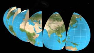
It also visualizes several other projections along the way
Ответить
It's amazing how south america pratically didn't change except for chile and argentina
Ответить
flat earth debunked
Ответить
❤️❤️❤️
Ответить
Mercator is way bigger than earth
Ответить
ok
Ответить
Our teacher used this, I have an exam of this tomorrow.
Ответить
Best explanation
Ответить
IDK why but I get mad when I see the Mercator projection.
Ответить
We're hurtling through space on a giant plant 😱🌳🌴🌴🌲🌲
Ответить
Mercator projection for trade not science
Ответить
Wait , so the whole world was cake
Ответить
Amazing video! excellent!
Ответить
Hola
Ответить
My life is a lie🙄
Ответить
Hola 2020
Ответить
Super vidéo bg
Ответить
This means the earth is flat :o
Ответить
Too good
Ответить
Hep merak etmişimdir neden haritalar böyle diye bi cahilliğimi daha fark ettim şuan mddldkdldn
Ответить
Not just the map itself but even the description: Haha..!
How funny...!
N-O-T

you see how along the equator/middle the map is to scale? what if we took another version of the map where the "equator line" is moved up to like norway? then, THAT latitude would be to scale but, everything south of it would be stretched. then continue and move the "equator line" and move it down to the latitude of south africa, then the bottom half of the map is to scale, while everything far far north is stretched. NOW what if we took all three of those maps and "blended them" if that would be even possible, technically you would have a like 90% accurate earth with the least amount of stretching... if someone knows how to do this please try it
Ответить
What If We Chop The Earth Into Smaller Pieces(Smaller Than Shown in This video)
Ответить
This is terribly misleading. Don't use this.
Ответить
the math for this please xD
Ответить
But why is there that final stretch in the end? What was the purpose of doing that back when it was made?
Ответить
These lines were useful as navigators were using only the compass to determine their direction, but that projection showed land in the northern hemisphere more than it actually was.
For example, maps using this projection show Greenland as roughly the same size as Africa, while in fact it is 14 times smaller, and South America looks as if it is the same size as Europe, almost double its size.

Do you think this is why flat earthers be the way they are?
Ответить
so stisfiying
Ответить
Wow.
Ответить
So I’m trying to wrap my head around this and I admit I’ve never even heard of this until last night while doing some ancestry research. Does the map stretching fill in “imaginary” gaps? It’s a genuine question.
Btw my last name is Cramer, bloodline of its inventor Gerhard Kremer, who is believed to be the cartographer who invented the "Mercator Projection" on which all maps are based.

I watched a whole bunch of five and six minute video explaining the Mercator map and and 40 seconds with zero words this person has made me understand
Ответить
Why is Russia bigger than Africa? You can fit 3 Russian continent's inside of Africa and still have room! Becuse Africa is not in the southern hemisphere and look at the size of Greenland I mean come on now wtf
Ответить
That final stretch though
Ответить
Really? From the viewpoint of the earth as a globe? You must be kidding. You should be sincere and truthful by explaining where do the globe earth comes from, to begin with. Has the earth ever been photographed to be exposed that way? NO! How those beautiful pictures come about then? CGI, Computer Generated Imagery. Because sorry to expose your underbelly, Grafonaut: no one has ever flown high above it to take any pics. That's what NASA says, but that is not true. Those who naturally will try to refute my words, they should first inform themselves about the highly radioactive van Allan Belt and the thermosphere not even 200 miles above our atmosphere.
Ответить
The problem with this visualization is that it uses plate carree as an intermediate state, instead of directly stretching to Mercator without distorting angles.
Ответить
sir allow me to use this for my class. i promise you its for educational purposes
Ответить


