Комментарии:

thank you for video, it was a great explanation.
Ответить
what's the best gps to get for a rover now?
Ответить
Awesome video... I really like your videos. Thanks bro . May Allah bless you ♥️♥️♥️
Ответить
Nice video.
What is the name of the app in the android smart phone please

What is DATUM LEVEL?
Ответить
do you have to use hot spots to do, how just cell phone wireless can be used to collect data too?
Ответить
Is it possible for a drone to access the base as well as the rover?
Ответить
What is the price for the set?
Ответить
Bro what is the price of this device
Ответить
Hello Rami , I am a freelancer I work on ortho, mapping, lidar and uav data too . I will be providing outputs like orthophoto,DEM ,DSM, colour point cloud,
CONTOURS and MAPPING.and data matching with gcp also.please contact if u need any DATA SET to be processed.

I’m struggling to understand just one thing… How could you know the coordenate of this point that you setup your base station if you “rent or buy” the RTK just for that reason? In my case i picked up some points using a total station, so the only reason im renting an RTK GPS is to reference a materialized point that i used as a base point for the total station.
I know that in someplaces you have a geodesic mark, a fisical mark, that has already known coordinates. But in a case that you don’t have this, can you just set up your base station anywhere you want and start yours measurements? I hope you understand my question, English is not my home language 😂 thanks for now

My rtk points I took on site shifted. I have known coordinates and have done everything possible but the issue still persist.
Ответить
Rami, thank you for the video. I have a challenge in using rs2 for staking out. Can i get your email so i can forward the issue to you?
Ответить
Great video!
Ответить
Dear if we dont have the coordinate of control point , whats can we do .
Ответить
God bless 🙌 bro
Ответить
I'm a surveyor in Brazil, but I'm living in London. I'd really like to take a course here to improve. Do you have a place to say thank you?
Ответить
Hi, if I have not known point for Base. For example If I have to survey or topography in area where there is no known gcp point, how I can start. I have base and rover setup same like in this video.
Regards.

Can use multiple bases with one rover, as the rover may be obscured by obstruction to the line of sight between rover and base but possibly visible to another base?
In addition, if the rover loses connection with the base what happens to the accuracy of the rover? does it just revert to the satellites GPS position

RAMI knows better what we need in surveying. Thanks RAMI
Ответить
1. What is the maximum distance permitted between the rover and the base station?
2. Is a direct line of sight required between the base station and rover? Will this technology work in a forest where trees may obstruct signals?
3. You referenced a known monument base station longitude and latitude coordinate. If you are in a wilderness setting how is this point obtained? If you are in an urban setting, how is this point obtained?

Useful thanks.
Can you introduce me a site that have completely learning survey equipments?
Thanks

Hi Rami, We normally input local GRID coordinates for the base station. Rover measures local GRID coordinates as well. Would you use Geographical (Lat, Lon) much? Thanks.
Ответить
Great Video!
Ответить
Hi everyone! Any one can give me advice on where to start if we like to establish a national coordinate system? and also what can be alternative ways to measure coordinate - so we can establish a place for the base station.
Ответить
Hi Rami, are you familiar with Sokkia Fusion technology? I’m having trouble making it work the way it’s supposed to.
Ответить
the conection bettween base and rover through radio wave you didnot explain
Ответить
Do you have a video explaining WGSxxxx ?
Thanks.

please Rami, confirm your base height measurement, you measure to the antenna bottom, phase centre or to antenna top. I think each manufacturer always indicates that
Ответить
Kindly ,, I need how I can use the localization option in GPS Sokkia GRX3 ??
Ответить
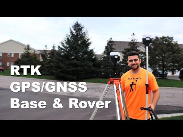
I love how he has RTK merch!!! Yessss! I am here because I work in Automotive DAQ hardware and need to learn more about RTK and how they could work together
Ответить
Thanks full of knowledge
Ответить
Awesome video. Would you make a video comparing the Emlid RS2 vs SparkFun RTK Facet L ?
Ответить
Wow Sir its nice video i salute you sir for job well done it is very informative a new technique. we you equipment in project sir slope protection as of I am company using total station in as stake survey road works and slope protection in the philippones
Ответить
RTK lost would be a funny shirt too lol
Ответить
Nice video it really help me. I’m just wondering if we have a base and a rover set up, is it still necessary to have a p4pro with the rtk module or not ?
Ответить
Hi Rami, is the radio connection between the base and the rover can through a dense vegetation or a building. I’ve noticed that he rover lost the fix green each time there is something in between the two recievers.
Ответить
Rami love your channel. I am new to surveying. I just go into the surveyors unions out in NYC. I start my CST class in October. I have a question about this particular setup I will try to make it not sound so confusing. I work for a construction company. We currently sun out all the survey work, they get the plans from the engineers and then they lay out the job site with a total station. I have a set of plans for myself and I use an automatic level to shoot grades they lay out for me. On the plans they have a section that has all known points and traverses with elevations, coordinates etc. if I were to get this particular unit you use and I set up the base station on known points, input the coordinates will I at least have the correct elevations? I know that I won’t have the layout of the job on there but at least having the elevations will help so I can walk the job site and check elevations on the road, manhole castings etc. it would be easier then setting up a level, and trying to mathematically figure out the elevations. Second question. Is there a way to import the engineers layout onto the app so I could layout a job site (drainage manholes, curb sidewalk etc) using this unit instead of a total station? Hope I didn’t confuse you.
Ответить
Finally a good explanation, and he gets 50k more views than one of the big suppliers.
Ответить
Can i measure elevation of the building from sea level ?
Ответить
Heyyy bro... please share more videos about RTK gnss...and i have a question... That you measured base height from ground to the pole of tribrach but in rover you measured the height from ground to rover's center... Why?...
Ответить
HOW TO SETUP (HI SURVEY Rtk ) plz help
Ответить
Hi Rami, I’m wondering if you can help this enthusiast understand how you find the exact coordinates for a point for the base station or a total station when needed. It seems to me many total station operations you need exact coordinates of a point and for the base station you also need exact coordinates. It seems to me it’s a bit like the chicken and the egg situation. How do you find that exact coordinates of that first point? I’m from the U.K. not the US if that changes anything.
Thank you.

@Hey Rami. I notice your using the Emlid GNSS receivers. I wanted to know what do you think of them compared to older brands like Topcon, Trimble and Leica. Is the Emlid better or why would the other brands be better or not?
Ответить
Hi Rami, is there available free apps for SinoGNSS? Thank you and more power to your channel!
Ответить
I have some concerns regarding the measurement of base station antenna height. You were measuring without installing the receiver on the tribrach. Doesn't the antenna reference point make sense? Shouldn't we measure the antenna height from phase of antenna?
Ответить
@rammi, good but fast
Ответить
Great video! You did an excellent job both explaining and demonstrating RTK.
Ответить