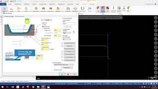
Estimation of Fractional Impervious Surface (FIS) from NDVI using ArcGIS Software
This video briefs about the significance of FIS in real world applications as it is one of the key variables considered for mapping Groundwater potential zones. FIS is largely unheard of but that in no way undermines its importance in reality as it is predominantly put to use in hydrogeological and subsurface studies around the world. We sincerely hope this video puts it on the spotlight for all the right reasons in future research purposes.
#fis #arcgistutorial #arcmap #ndvi #fractionalvegetationcover #fractionalimpervioussurface #groundwater #remotesensing
#fis #arcgistutorial #arcmap #ndvi #fractionalvegetationcover #fractionalimpervioussurface #groundwater #remotesensing
Тэги:
#GIS #Remote_Sensing #TutorialКомментарии:

@RockJack-px3ss - 22.03.2024 06:08
Very good. Help me a lot!😁
Ответить
Estimation of Fractional Impervious Surface (FIS) from NDVI using ArcGIS Software
Carto Geospatial Solutions
Дриблинг Мужикова в игре против "Атырау"
Ultimo Libero
How Easy It Is For The US President To Launch A Nuclear Weapon
Business Insider
Lathe Lesson 1 Tutorial
Thaddeus Stevens Machine
Elements of a Mystery | Reading Genre Lesson
Help Teaching
How to Write Crime Fiction: How a Mystery Works
MichaelSantosAuthor
Creating a tool library , custom tools, and tool assemblies
Thaddeus Stevens Machine


